Rainow road reopens after major embankment repairs: what residents need to know

The B5470 Macclesfield Road in Rainow has reopened to traffic ahead of schedule after a major repair scheme following an embankment collapse between Ginclough and Kettleshulme.
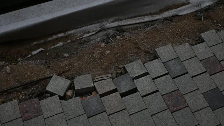
Cheshire East Council said the route reopened after highways teams completed complex works to stabilise the hillside, rebuild the road and improve drainage. The closure had been in place after part of the road and embankment gave way in January 2025 following significant rainfall.
The reopening restores a key local link for residents, businesses and road users in the area. Works will continue on site for a short time while the temporary footbridge is dismantled.
B5470 route open again between Ginclough and Kettleshulme
The affected section of Macclesfield Road runs through a rural part of Rainow and connects communities near Ginclough and Kettleshulme. Its closure caused long-running disruption for people using the B5470 for local journeys, school runs, work trips and access to nearby villages.
The council said the road had been due to reopen in several weeks, but teams completed the main highway works early enough for traffic to return sooner than planned.
| Detail | Confirmed information |
|---|---|
| Road | B5470 Macclesfield Road |
| Location | Between Ginclough and Kettleshulme, Rainow |
| Cause of closure | Road and embankment collapse after heavy rainfall in January 2025 |
| Current status | Reopened to traffic ahead of schedule |
| Remaining work | Temporary footbridge to be dismantled |
For readers following similar rural highway schemes, Munisha has also covered how local road maintenance and drainage work is being handled in another village setting.
Drainage failures shaped the repair work
Before reconstruction could begin, the site required ecological, geotechnical and drainage surveys. The location, steep terrain and condition of the existing road meant the project had to be treated as a wider civil engineering repair rather than a simple resurfacing job.
During construction, crews found previously unidentified land drains. Cheshire East Council said it is suspected that a break in one of the historic pipes contributed to the hillside collapse.

The repair scheme included 64 metres of new land drains, new surface water drainage gullies, headwalls to improve water flow and additional manholes for long-term inspection and maintenance. Those measures are intended to make the road more resilient during periods of heavy rain.
Thousands of tonnes removed and reused
Councillor Mark Goldsmith, Cheshire East Council cabinet member for highways and transport, said the closure had caused significant disruption but that the collapse left the authority with no option other than a full stabilisation and rebuild.
He said more than 4,000 tonnes of sand, spoil and old road surface were removed and recycled during the works, a volume the council compared to the weight of around 2,700 family cars. The large amount of sand removed from the hillside was sold to a building company for use in construction.
More than 5,000 tonnes of aggregate and soil were then used to rebuild and strengthen the embankment. The area has been seeded so the repaired slope blends into the surrounding landscape.
National park setting added limits on the scheme
The section of road sits within a national park, so the rebuilt embankment and highway works had to be managed with the landscape in mind. Vegetation was cleared along the route, and the carriageway has been fully resurfaced as part of the wider drainage and reliability improvements.
Goldsmith said the project reflected the difficulty of working in a constrained rural location while removing and reusing large quantities of material safely.
“We have now made significant improvements to the drainage infrastructure to help increase resilience during periods of heavy rainfall,” he said.
Source: Cheshire East Council
Source check Source trail
This report is based on Cheshire East Council's published update about the B5470 Macclesfield Road repair scheme.
- Confirmed the road named in the source as B5470 Macclesfield Road.
- Checked the affected stretch as between Ginclough and Kettleshulme in Rainow.
- Verified the stated cause as a January 2025 embankment and road collapse after significant...
- Matched the remaining disruption to the council's note that temporary footbridge removal w...
- Source
- Cheshire East Council
- Scope
- Rainow
- Updated
- 2026-05-29 16:47
Source check
Report a trust issue
Send a clear signal to community moderation if the source, facts or context need review.

Comments